4,720 shipwrecks · one app

What thesea ishiding

Pull the water away and the seabed is a museum. Wreck Lens puts 4,720 of its exhibits in your pocket, from a Bronze Age trader lost around 2150 BC to the liners, warships and U-boats of the last century.

Coming soon to the App StoreSee inside

For iPhone and iPad · iOS 17 or later · works offline

A wooden wreck resting on the seabed as the water drains away
2,813Charted positions
3,036With a photograph
111Wars and conflicts
Scroll

On the seabed tonight

  • RMS Titanic1912North Atlantic1,500 lost · ice
  • HMS Hood1941North Atlantic1,415 lost · 3 saved
  • HMS Royal George1782Spithead900 lost · foundered
  • HMAS Perth1942Java SeaFound in 1967
  • Mary Rose1545The SolentFoundered
  • Endurance1915Southern OceanLost to the ice

Inside the app

Every ship has a last voyage.

This is a reference you read, not a chart you navigate by. One wreck per screen, then the whole story underneath.

The feed

One wreck per screen.

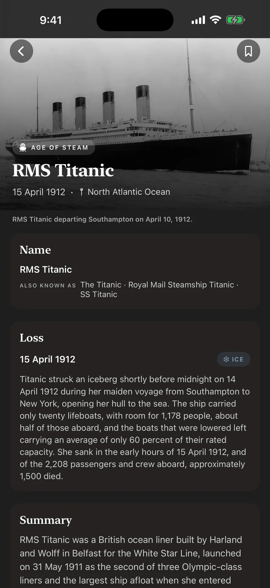
A full-screen feed you swipe like any other, except every card is a ship that never came home. The photograph, the name, the date, the sea she went down in, what sank her and how many were lost. Swipe up for the next.

  • 4,720 wrecks, free to browse
  • Filter by period, from Antiquity to Modern
  • Jump straight to the map from any card
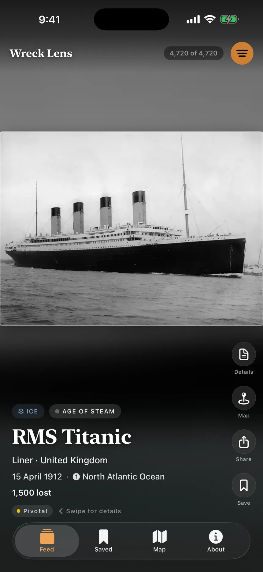
The Wreck Lens feed showing RMS Titanic

The dossier

Everything the record holds.

Swipe left for the full entry. The ship: builder, yard, tonnage, length, owner and master. The loss: date, cause and who or what did it. The people: aboard, lost, saved, missing. Then the sources behind it, with links.

  • Written summaries for 4,603 wrecks
  • Sister ships labelled as sister ships
  • Related wrecks, one tap away
The Titanic dossier in Wreck Lens

The map

2,813 wrecks, where they lie.

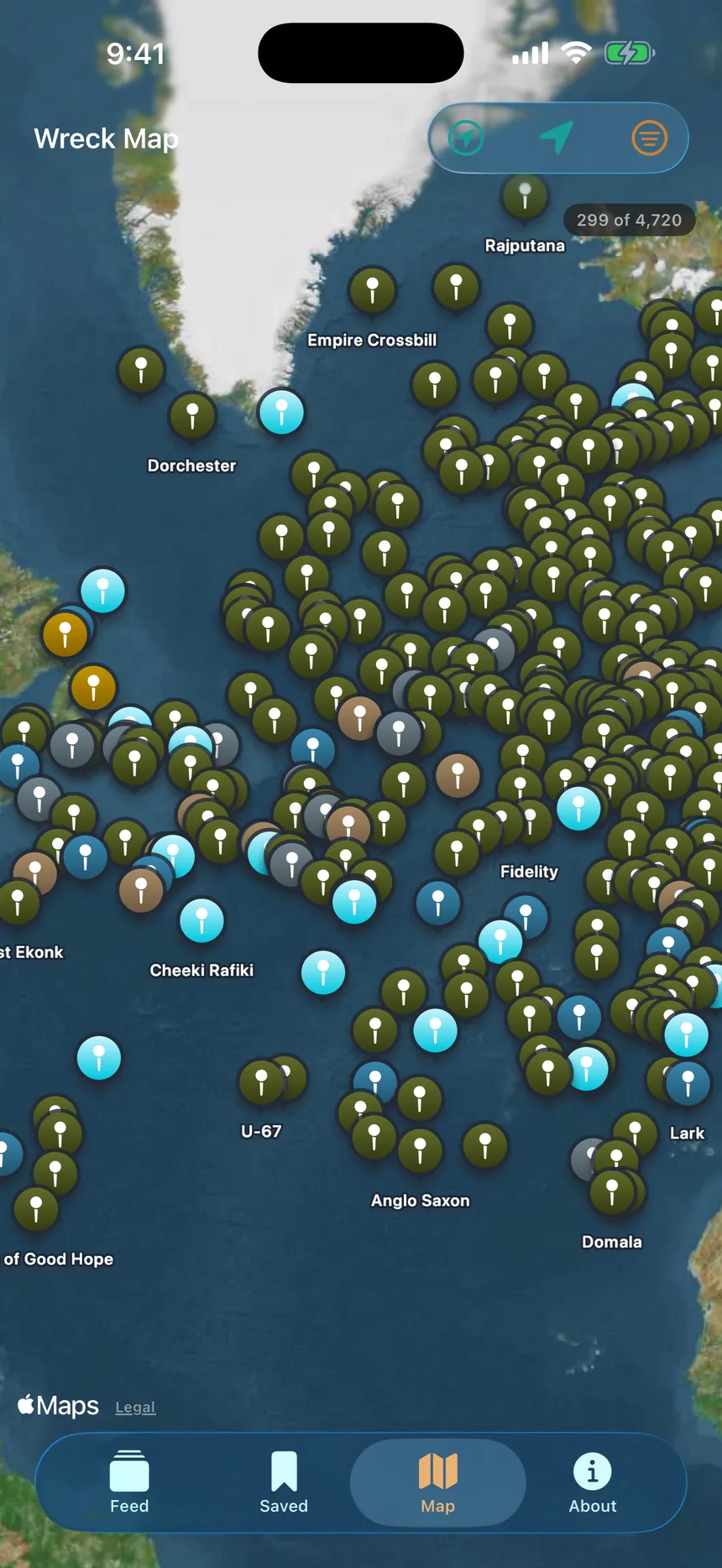
Every wreck with a published position, plotted on a world map and coloured by period. The convoy routes of the North Atlantic fill with pins. Tap one for the full entry, or press Map on a card to fly straight to where she went down.

  • Positions as published by official sources
  • Accuracy marked: exact, approximate or area
  • Locate me, and wrecks near you with Pro
The Wreck Lens map of the North Atlantic, covered in wreck pins

The wreck today

Found, photographed, remembered.

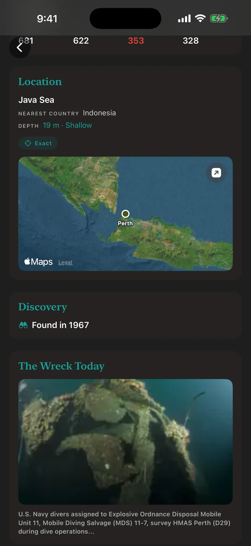
When was she found, by whom, on what expedition, and what is down there now. Where a diver or a survey has photographed the wreck, the photograph is in the dossier, next to the depth and the position.

  • Depth bands from shallow to abyssal
  • Discovery year, finder and expedition
  • War graves and protected sites marked
Discovery and The Wreck Today sections for HMAS Perth

Filters

Torpedoed, mined, lost to ice.

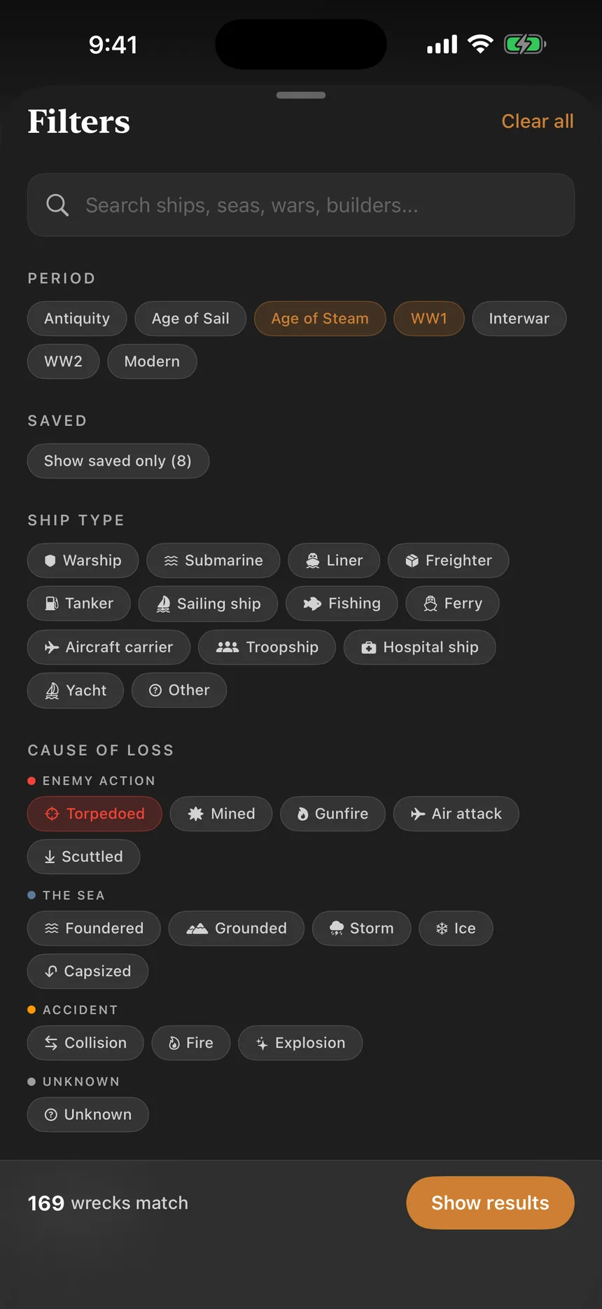
Fourteen causes of loss in four families: enemy action, the sea, accident and unknown. Combine them with ship type, depth, period, war, region, protected status and the decade a wreck was found. The count updates as you tap.

  • 13 ship types, 14 causes, 111 wars
  • Year range from 2150 BC to today
  • Search by ship, sea, war or builder
The Wreck Lens filter sheet

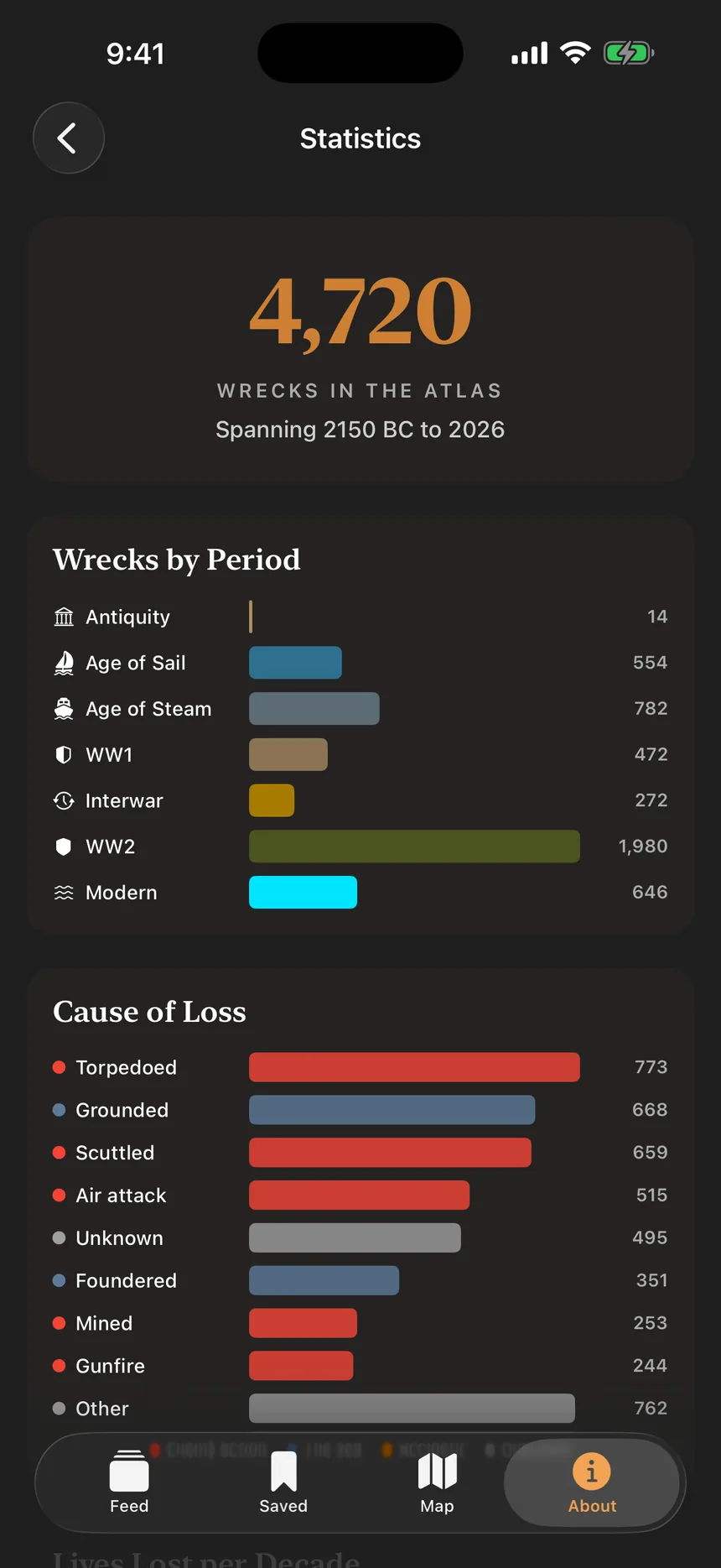
Statistics

The archive, in charts.

Wrecks by period, causes of loss, lives lost per decade, the deadliest wreck, the deepest located wreck and the longest wait for a discovery. All computed on your phone from the same 4,720 records.

  • Lives lost per decade, from before 1700
  • Worst year at sea
  • The busiest sea
The Wreck Lens statistics screen

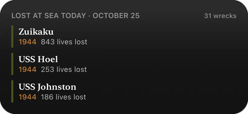
Lost at Sea Today

The ships lost on this date.

A Home Screen widget that shows which ships went down on today's date, most significant first. Tap a name and the app opens on that wreck. Part of Wreck Lens Pro.

The Lost at Sea Today widget listing Zuikaku, USS Hoel and USS Johnston, lost on 25 October 1944

Seven layers

Four thousand years of sediment.

The archive runs from a Bronze Age trader off Dokos to losses still being recorded. Each period keeps its own colour across the feed, the map and the statistics.

4,720 wrecks in all

  1. Modern1946 to today
    646
  2. Second World War1939 to 1945
    1,980
  3. Interwar1919 to 1938
    272
  4. First World War1914 to 1918
    472
  5. Age of Steam1830 to 1913
    782
  6. Age of Sail1500 to 1829
    554
  7. AntiquityBefore 1500
    14

Protected sites

Some of these are graves.

Wrecks that are war graves, protected wreck sites or memorials are marked as such in the feed and in the dossier, with a note asking you to respect the site and those who were lost. Positions are shown only as published by official sources.

This app will not help you take anything off the seabed.

No signal needed

Offline. Actually offline.

No account

Nothing to sign up for. Open the app and read.

No tracking

No analytics, no ads, no third-party code. Data Not Collected.

In the app

All 4,720 records and every photograph ship inside the app. Only the map's background tiles come from Apple Maps.

Pricing

Free to read. Pay once for the tools.

Wreck Lens

Free

The entire archive

  • All 4,720 wrecks in the feed
  • Full dossier for every wreck
  • World map of 2,813 wreck sites
  • Filter by period
  • Statistics
Coming soon to the App Store

Wreck Lens Pro

$4.99

One-time purchase · no subscription

  • Search every wreck
  • Advanced filters: ship type, cause, depth, protected status, discovery
  • Saved wrecks
  • Wrecks near you, 25 to 500 km
  • Lost at Sea Today widget
What Pro unlocks

US price shown. The App Store sets the price in your country.

Every ship hasa last voyage.

4,720 of them are waiting on the seabed.

Coming soon to the App Store

Made in the Netherlands by Mircules